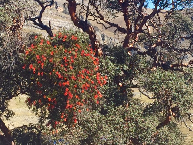
The next day was spent preparing for our 10 day trek on the Huayhuash Circuit approx 100 kms South of Huaraz. The Circuit is 110 kms long and can take between 7 and 14 days. It involves climbing 5700 vertical metres and reaching a maximum altitude of 5060 metres. Most people take 10 days to complete it. The Huayhuash range is 30 kms long by 15 kms wide and encompasses 3 major summits over 6,000 metres, countless other razor sharp peaks, bejewelled alpine lakes, chaotic ice falls, girgantuan rock faces and fascinating contorted strata.
Firstly, we gathered quotes from several agencies for the full monty (guide,cook,donkeys) the half monty (donkeys and donkey driver) and the DIY (no donkeys). After analysing the quotes and assessing what type of experience we were after we settled on hiring a donkey driver, 4 donkeys, a cooking tent, a big pot, 4 wooden boxes and booking private transport to the start of the trail at Quarterhuain. (We had chosen to pay the extra money ($US159) for a private shuttle as it dropped us off at Quarterhuain instead of taking the local bus (25 soles per person) which stops in Llamac - this saved us a long walk up a dusty gravel road.)
Next we prepared a shopping list for 5 people (we had to feed the donkey driver as well) and hit the local markets and shops. Our shopping list looked a little like this: potatoes, pasta, rice, lentils, avocados, cheese, tomatoes, carrots, onions, bread, biscuits, cake, fresh fruit, canned fruit, instant puddings, nuts, raisins, chocolate bars, banana chips, rolled oats, muesli, yoghurt. As we had donkeys to carry the food we were able to take as much fresh produce as we wanted. This was quite a different approach compared to shopping for a NZ tramp where you have to carry everything yourself. It was a bit of a mission traipsing it all back to the hostel but a good way to interact with the local stall holders. Something we have learned since being in Peru, is that the locals never say no, whether it be answering a question on directions somewhere or giving a straight up answer to will the Lady finger bananas last for 9 days?
At the end of our 5 or so trips into town our small hostel room was full to the brim. Not only were our panniers and clothes sprawled all over the place, but the wooden boxes and shopping bags full of food for 10 days filled every space in the room! What a sight! It was a late night for us - repacking and recounting all of the boxes of food to make sure we didn't have too much food, but also that we had enough!
To help plan our route we used the Pikes on Bikes new book "Peru´s Cordilleras Blanca and Huayhuash."Neil and Harriet Pike - this book was extremely useful and provided us with detailed and extremely accurate route information. Some of the trails were not accurately shown on our map so without this book as a guide we couldn´t have done this trek unguided. If you are planning on trekking in this region it is a must - check out www.trailblazer-guides.com for details on where to buy it.
Trek start day.
Sleeping Height: 4,170m
Campsite: Quartelhuain
The alarm went off at 5am and we jumped out of bed and began taking all the bags and wooden boxes to the front gate ready for our private taxi to take us to the start of our trek and to where we would meet our 4 donkeys and donkey driver. It was a pretty scary four hour drive, 2 hours on gravel up a huge valley. The road consisted of steep switchbacks up and down massive stony hills. We tried not to look out the window down the sheer cliffs as we bumped our way along the narrow gravel road. We arrived at our drop off point at Quarterhuain at 11 am to be told our donkeys and driver were going to be 4 hours late - bugger. We had no choice but to pitch our kitchen tent and wait. We waited and waited, and waited. So much for our early start ... Once it got to midday it was too late to start walking to the first campsite and the wind had got up so we set up camp at the designated campsite by the road and kept waiting.
Our donkeys and driver finally turned up. at 4.30pm. We were not sure if there was a miscommunication with the agency and donkey man...or if he was just slack at arriving. This meant we were no longer able to start walking as it gets dark and cold by 6pm. Our donkey driver Christian seemed nice and we managed quite well communicating with him in our basic Spanish. Debbie went over the Topo map with him, showing him our planned route and renegotiating with him to suit the needs of his donkeys. Together they came up with a final route plan that they were both happy with.
Each community sells you a ticket for passing through their area and using their campgrounds. In some instances they block the path, lock the gate so they definitely get their money. There are 9 communities and the total cost is approx NZD100. (250Soles). That afternoon we paid our first fee to one of the local ladies. It was a rare chance to interact with the locals and nice that they always take the time out to ask the usual questions. Where are you from? Where have you come from today? and Where are you going to next?
Day 2
Quartelhuain to Mitucocha camp
Sleeping height: 4,260m
Highest point: 4,690m
Walking time: 4 hours
The night was pretty cold but our Express 400 sleeping bags zipped together worked a treat. We talked to several couples the following day and encouraged them to do the same as it certainly makes for a warmer and more comfortable night sleep. The next morning our water bottles had ice floating in them and the tent fly had a coating of ice inside.
 We got up at 7pm and cooked porridge and coffee. This became our morning staple and by the end of the trek we had the routine down pat.
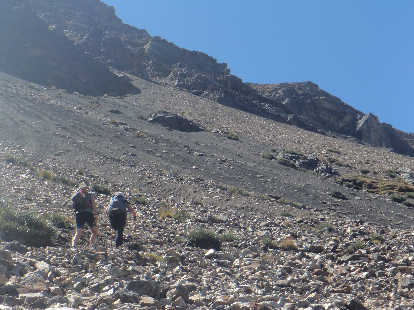
We started off walking at 8am. Debbie had been in charge of taking down the tent and her hands were freezing. After 20 minutes we stopped and rechecked the map. Debbie was white and felt nauseous .... after rubbing her hands and changing to some thicker gloves she started talking again and then vomited several times. That seemed to do the trick! She reassessed the map and realised we were in the wrong valley. Luckily, she made a speedy recovery or our detour may have been a lot worse. We sidled around to the next valley and were on track before too long. It took us 2 hours trudging steeply uphill with numerous switchbacks to our first pass, Cacananpunta at 4690 metres. Huayhuash range. Shortly after we came to a locked gate at the local village (2 houses) where it seemed the entire village was waiting to collect our money (7 people) and let us pass. We arrived at our destination early afternoon so spent the afternoon walking up to view a nearby lake Mitucocha.


Going over our route choice with our Donkey driver

Day 3
Mitucocha camp - Carhuacocha
Highest point 4,870m
Sleeping 4.160m
Walking time: 3.30 hours
Today's pass was up a gentler slope on mainly grasslands. Initially, we lost the views of the mountains, but after 2 hours of walking the mountains were once again revealed and wow the views were even better than the day before. We chose an incredible spot for lunch and relaxed in the sun gazing at the surrounding lake, 5 peaks and 4 glaciers. We arrived at our campsite around 1pm. The campsite was situated at the far end of Lake Carhuacocha in full view of the surrounding mountains.


Day 4
Carhuacocha - Huayhuash
Highest point 4,830m
Sleeping 4,160m
Walking time: 6 hours
Today was our first full day of walking so we were up and ready to walk by 7am. There was no sign of Christian our donkey man or our donkeys. We set off anyway hoping that our gear would be safe and that he would be at the next campground to meet us. Today was also the first day we walked on a detour route instead of following the donkey trails. It was nice to be off the main drag and away from the other groups. The path was much narrower and we were forced to consult our map and guide more often. We followed a path around the lake, then angled off through a valley carved by a glacier. We then skirted passed 4 alpine lakes surrounded by massive piles of moraine (rock and rubble pushed in front of a glacier).

We were also treated to many avalanches, thankfully on the far side of the lake as the sun hit the snow slopes. Once we passed the four lakes - Carhuacocha, Laguna Siula, Laguna Quesillaococha and Laguna Gangrajanca. We climbed what was described as a precipitous slope out of the valley and it was so steep that we had had to rest every few steps.The precipitous climb


Once over the pass, Siulapunta at 4830 metres the path gently sloped downhill for 2 hours to our campsite. This campsite was much larger than others in the area and had the best toilets yet


Day 5
Huayhuash - Viconga
Highest point. 4.780m
Sleeping 4,360
Walking time: 4 hours
We had hot pools to look forward to that night so we left camp at 7am encouraged by Christian to start early.We walked up to a gently sloping pass in full view of a pyramid shaped mountain -Nevado Trapecio, before descending into a gorgeous valley. The scenery today not as spectacular as previous days, but we had great views of lago Viconga which had a small hydro station. We arrived at camp (Aqua Caliente reasonably early and spent the afternoon hanging out in the hot pools. They were to die for - 3 concrete rectangular deep and slippery havens of warmth.While we were hanging out in the pools Christian got very drunk with two other donkey drivers. There was a small shop by the hot pools selling coke, beer, yogurt and chocolate. We bought yogurt! Christian then passed out under a donkey blanket outside in the freezing cold after Emma told him he was being unprofessional and he could not have one more beer - we are still not sure why he decided to ask Emma´s permission for that last beer!


Day 6
Viconga - Cuyoc camp
Highest point 4,950m
Sleeping 4,550m
Walking time: 4 hours
We started our day with another soak in the hot pools. Once again our tents had frost all over them but it was a small price to pay for clear and stunning night skies. The stars were incredible.

Our walk to the top of today's pass Punta Cuyoc was mainly on grassland. Part of the way up we came across hundreds of black, plump, furry caterpillars - they were crawling up a dirt slope then rolling back down - so funny. Susan commented that it remind her of the cycle of daily life - working your butt off to get somewhere then falling down again only to have to pick yourself up and give it another go..


Whoop whoop gotta love the downhill bits !
Today our donkey driver explained that he had spent all his money on beer and asked if we could pay the grazing fees for the donkeys at the next three camps. Mmmm we were not particularly impressed.
Day 7
Cuyoc camp to Cutatambo - via Paso Jurau with a side trip to Sarapococha
Highest point 5,080m
Sleeping 4,270m
Walking time 9 hours

Can you spot the Vicuna?

Climbing up Paso Jurau


On top of Paso Jurau

The rocky but safe descent

Making friends with the locals

Stunning views on the way down of Lago Jaraucocha

Bliss


The hills are alive with the sound of music


Peace and tranquility at our afternoon tea spot

Stunning
We got back to camp around 4pm - what a day...
Day 8
Cutatambo - Huatiaq
Highest point 4,270m
Low point 3,500m
Sleeping 4,270m
Walking time: 6 hours including a side trip to Huayllapa
This was the first day where we had no pass to climb so no tough uphill! this is Peru so ... yeah right! We descended below 4,000m - the only time on the trek..Our day started with frosted tents yet again, frozen drink bottles, wet undies left outside as stiff as boards.We walked for 4 hours down a valley following a river that cascaded over huge boulders giving us many waterfalls. As an added bonus we found ourselves walking through fragrant lupin bushes.We also came across a calf which Richard patted and we named Michelle - she followed us for two hours. We closed two gates and Michelle just busted through. Eventually we came across some farmers and Emma gave them the calf. Happy as farmers.


Restocking our bread supplies
On our way down we met Christian (he with no money at all) climbing out of the town on his horse with a bag of bread, a coke and a horse shoe - hmmmm! We have started to think we have been tucked money wise.We sat in the town square (think dusty with a few flowers and benches) and ate fresh bread and avocado. It was Saturday so most of the town was at the local athletics day complete with brass band playing and someone who liked the sound of their own voice yelling over the loud speaker system.There were three kids that shyly hung around us, one getting brave and getting closer. Emma gave them a carrot and some lollies.And then we began what our book described as a "slog uphill" of 2 hours - very accurate description. No sun this afternoon so it was extremely cold.
Day 9
Huatiaq - Inchhuain
Highest point 4,610m
First pass 4,790m
Second pass 4,850m
Sleeping 4,060m
Walking time: 6 hours
Our book says "The circuit nears its end with a bang!" Today we went over two passes Tapush Punta and Yaucha Punta. We had camped only halfway up the slog from yesterday so continued up another 2 hours. Yes that made a 4 hour hill! The countryside here is just so big - photos cannot capture it at all.
The scenery to the first pass was not particularly exciting but the second pass made up for the first.
We dropped down steeply after the first pass, sidled around a hill and came across the first trees we had seen on the trek. Wow!
Emma got to ride Christian´s horse for a bit


Quenuales trees

Paying for the tickets to enter this community


The second pass had several levels, we climbed, then traversed the pampas (swampy grass flats), climbed scree, traversed pampas, climbed again and eventually made the top for once again magnificent views of mountains and alpine lakes.

The highlight of the day had to be sitting on top of the 2nd pass eating our lunch and having a condor fly overhead so close to us. We could hear the wind in his wings and see the individual feathers.

From the top of the pass we traversed along a ridge line with the land dropping away steeply on either side - we felt like we were on top of the world.It was then a drop straight off the edge for 30 mins to the donkey trail below and a further 30 mins walk into camp. What a descent !


Day 10
Inchhuain - Llamac
Highest point 4.270
Walking time: 4 hours 30 mins


Our last highpoint

Richard diving into his bag to get his phone - the first phone coverage in 10 days !!

Heading down to llamac and the bus

On arrival back in Huaraz we showered then celebrated our awesome trek with several pizzas, and a bottle of wine.
The entire Huayhuash circuit was an amazing experience and one of the best treks we have ever done. We can´t rave enough about it - it was the perfect way for us to recharge our batteries and get our headspace prepared for continuing our cycle North towards Ecuador ...
Weather
We were so lucky with the weather. While freezing at night and morning it was sunny most of the time. We had one night it rained for about an hour but we were finished walking so we sat in our cooking tent until it cleared. June seems the perfect time to trek this circuit provided you have sufficient warm clothing and good sleeping bags.
Gear taken per individual
2 x merino socks
1 x Montrail hiking shoes
1 x merino long johns
1 x thermal tights
1 x cross-terrain zip off short trousers
1 x reflex overpants
1 x merino singlet
1 x merino tshirt zip
1 x merino longsleeve zip
Primaloft puffer jacket
1 x polar fleece top
Traverse jacket
1 x yowie
1 x thermal gloves
1 x merino beanie
1 x windstop gloves
1 x Express 400 sleeping bag
1 x silk liner
4 x Sealine drybags
1 x headtorch
1 x ResQlink PLB
1 x titanium spoon
2 x anodised aluminium pots
2 stoves
2 x white spirits
1 x flint
1 x 40 liter Amp pack
The nights were extremely cold and we needed all this gear to be just comfortable - never underestimate the cold at altitude ... brrrrrrr
Our Costs
Donkey USD8 per day
Donkey driver USD16 re day
Food USD 200
Food boxes (4) USD 2 each per day
Kitchen tent - USD 5 per day
Cooking pot - no charge
Private mini van ( good quality) USD159
Bus back S25 per person
Community tickets S250 per person
So roughly about USD240 per person
Or NZD 344
No comments:
Post a Comment